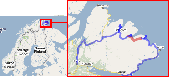
Before 2010, I've been to polar Norway twice - cycling in 2003 (ru) and in a family car trip in 2008 (ru). For sure there are lots of other nice places around, but I fell in such love with this "end of the world" that this love evolved in a new "trip concept": the farthest north-east Norvegian peninsula, Varanger, is almost encircled by roads. Almost, that's the key word. About 20km is not connected with any kind of path. Sounds like a goal: to close this loop in a mixed cycling-and-bike-carrying event.
Bus to my starting point, Tana Bru, starts from the Finnish Lapland capital Rovaniemi in the afternoon (Lapland bus schedule here BTW) connecting with a morning train from my home Helsinki. That meant getting up at some 4:30AM and riding in train+bus for 20 hours. I also had to disassemble and wrap my bicycle to be admitted to a "Pendolino" train on the night before the departure, which takes quite some time.
By 0:55 I'm finally at the destination, Tana Bru. The only thing I needed there was an ATM to get some Norwegian cash. Fortunately, it was found just at the bus stop.


My intention is to camp by the roadside as soon as possible (it is daylight even at 1:00 now, but still riding during the daytime is nicer). Somehow there is no "promising" place along the road 890. I had to pedal about 8 km before laying down at some place of "mediocre quality" by far-North standards: there was no nice waterline nearby. But that did not matter after over 20 hours of the road.
The weather is fantastic. Clear sky, about +15°C, and -- that's especially hard to believe -- tailwind.


So far the road is flat. I make a small fork to Høyholmen natural reserve - a gravel road along a thin spit protruding over two km into the foreshore. Nice table with benches serves as lunch place. Road signs at Austertana show some "Restaurant/camping", but I did not turn there to check. Gradually the path is raising up to the heights; not really much above the sea level, just some 200 m, but at this latitude, it means opening of the space and no trees any more.


We cycled this segment in 2003. I got full with nostalgic feelings.


Right after fork to Nordfjord, where I plan to go still today, I leave the panniers in roadside bushes and continue unloaded to Båtsfjord. The town has a number of sculptures, more than one department store, several fast food cafes open until 22, and a restaurant which I visited. This was the only time when I ate full meal indoors in this trip -- there were either no more eating places along the route, or they were already closed by the time I arrived.


It was a must to acquire about 330 meters of height to get to the foots of a radio mast. Pictures do not deliver the feeling how huge that mast actually is. During the uphill - part of which required my lowest 22:32 gear - I watched the Hurtigruta ship entering the harbor.


Today's camping spot was found, or selected, on the road to Syltefjord, not far from its fork. I expected it to be a "very quiet gravel road"; gravel it was, but not quite quiet by polar standards. Cars were passing regularly, maybe once in 15 minutes. Mountain ridges around are lit with the night sun rays.

145 km, 8:07 riding time
The sun is almost frying! It's hot (by polar standards again, meaning that the jacket is not necessary and I'm riding in a long sleeve jersey). The day has been started with bathing in a tiny lake just next to the tent.
About a kilometer before Syltefjord, there is a "natural phenomenon" (I read about it at baatsfjord.info): the "Stone bridge". I have not understood from the writing, how it has developed. It's not hard to reach it leaving the bike at the road, although some jumping over rocks is needed. I managed to do it not changing the cycling shoes.


A very promising roadsign - motor sledge trail to Hamningberg! That's just what I need! This means there is a path without mountain climbing at least. Well, there can be swamps (which is not an issue for motor sledge). Later, I have not seen any traces or signs of this trail.

Syltefjord has as many as two cafes, both were open. One of them is advertized by nice-looking decorated signs "Stauran cafe and camping". That is a place "with an attitude"! All interior made with "natural materials" only - wood stumps, boughs, reindeer fleece; all walls covered with souvenirs, which, as I understood, the owner makes himself. Almost always the so-called "local souvenirs for tourists", normally made in overseas lowcost counties, are tasteless and dull almost to be repulsing, at least to me. This place was an exception. I would have bought something, if only I had not need to carry it in the panniers along a way, about which I do not know anything yet.
The second cafe "at a tourist information" did not have that much "attitude", but a larger hall and wider selection of pastries.


...And now I have arrived to the key point of my route: river Syltefjordelva, which needs to be crossed. I did not figure out in advance, how big it is and what are the crossing options. But already when I was riding along it, I saw that this is nothing like Amazon. Now, at the river mouth, I took the decision that I will just ford it. To see all the options, I rode also to Hamna (Harbour) and looked at the opposite coast. At a distance, looks "walkable". It was probably possible to search for someone with a boat who will sail across, but I decided to ford.

Everything packed into dry bags, spare inner tube pumped and tied to the bike, and I have crossed the river mouth in two passes - first carrying the panniers on the back, second with the bike on the shoulder. It was never deeper than until the hips, and by reason unclear to me not really cold. I even bathed in the river which just crossed.

 Until Jonnejokka there was something
which probably can be called a trail. I could easily roll the bike
with the panniers on it. After its crossing (depth = up to knees)
trail traces became less discernable and I had to switch the panniers
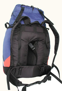
into the backpack mode. I have a "single-volume", 80l capacity
rear pannier(s) with real shoulder straps and belt. While carrying on
the back is of course not exactly as comfortable as
a backpack designed for it, it still quite possible to walk long distance.
And, for weightweenies: 80l pack itself weights 1400g. That is less
than two Ortlieb panniers which would take 50l and can not be
carried separately from the bicycle. I do not see how such combined
"cycling-bike-carrying" could be possible without such
pannier/backpack. Well, it is not waterproof.
Until Jonnejokka there was something
which probably can be called a trail. I could easily roll the bike
with the panniers on it. After its crossing (depth = up to knees)
trail traces became less discernable and I had to switch the panniers
into the backpack mode. I have a "single-volume", 80l capacity
rear pannier(s) with real shoulder straps and belt. While carrying on
the back is of course not exactly as comfortable as
a backpack designed for it, it still quite possible to walk long distance.
And, for weightweenies: 80l pack itself weights 1400g. That is less
than two Ortlieb panniers which would take 50l and can not be
carried separately from the bicycle. I do not see how such combined
"cycling-bike-carrying" could be possible without such
pannier/backpack. Well, it is not waterproof.


I had quite a good heartbeat level when arrived to the Østerelva lagune, that is if I have had a meter. Large, dry (rarity in polar latitudes), open space with the river mouth in its eastern end. After crossing it, some uncertainty hit me: what if this is just Jonnejokka? In this case, I'm badly behind the schedule and must catch up. I did not have GPS map but just the receiver (in the phone) which showed degrees with decimals, and the paper map had degrees and minutes marked. After realizing that I can't convert between the units in the head, I understood without any further "uncertainty" that my roof is about to be gone and the only option is to settle the camp. Thanks to some of my past trips, I know where solo hiking in such mental condition can lead. Fortunately, I had no serious accidents, but enough of situations where you do not understand afterwards, "was it really me who went as crazy as to do THAT?". But after the heartbeat returned to normal, decimal degrees were successfully converted to minutes, and it became crystal clear that this is really Østerelva and I'm in fact going ahead of my plan.
The camp is excellent. Sun would warm up the tent all the night. Tender breeze blows away mosquitos (not much of them anyway). From what I can see now, conquering the mountain slope should be easy.

Bathed in the Barents Sea. Those who have been there know that this is not a routine event. Most of time the water is dead cold, most of shore is just large, sharp and slippery rocks. Fortunately, here, right at the river mouth, the water is already real seawater, but the shore is still almost a river shore - sandy. That's a real gift from the nature. Definitely, seawater means also Barents sea temperature, i.e. "dead cold".


Now, the romantics starts - or ends, depending on your attitude. Acquainting 400m of height walking with the bike was in fact easy in the beginning, I could roll the bike while the slope was green - covered with moss. The final "step" to the plateau required carrying. In fact I did not have too much of weight, if you do not think the ultralight standards - about 12kg bicycle and about 10kg backpack. But of course the bike on the shoulder is not as easy to carry as the backpack load, so that felt much more than just 22kg backpack. I had to make stops.


...And finally I arrive to the lakes on the saddle point. There is no actual mountain pass; it's rather just a flattening on the plateau. The water can flow either way. This is the top of the trip, in both literal and poetic sense.
Silence. Rare shrieks of polar gulls. The feeling is similar to that on the Polar Ural, except that now there is no mosquitos at all. That's a difference between Norway and Siberia. One of the many.

At first, I almost could ride the bike downhill. But that did not last long. I had to carry my iron (titanium, to be precise) horse about 5-6 kilometers. I defined three "riding grades" corresponding to the rock size. When the average rock diameter is about 5 cm, it is possible to ride the bike. From 5 to 10 cm I could roll it with the panniers on the rack. Between about 10 and 20 cm, one can try to roll the bike unloaded carrying the panniers in the backpack mode. Over some 20 cm, any rolling is imposible and the bike has to ride on me, not the other way around.

Sharp change of the landscape happens at the point where the power line delves into the valley Gunnargamdalen. Steep way down was the last carrying segment. In the valley I immediately find almost ridable path.


Syltevikmuan is the entry to the "inhabited world" - it's the start of the track road accessible to cars. "The loop" can be considered to be closed at this point. Since now, it will be cycling only.


Asphalt road to Hamningberg -- I have no other words than platitudes. Harsh, scarce. North. Subarctic.


Hamningberg is (now) a summer-only village with some dozen of houses. And a cafe, which is open one month a year. And no cellular coverage.


I camp in the western part of the peninsula. It's almost on a walking path, but there is no other choice, it's just sharp rocks everywhere. It would have been noticeably harder to find the spot if my tent had been 10cm longer or wider.


Heavy rain in the morning. I thought I'd have to pack under the tent. But just when I finished breakfast, the rain ceased.
The weather has changed. It's cold, wet and windy - now this is what's considered normal for 70 degrees latitude. I turn on the mode "put on everything I have" - cap, gloves, waterproof pants. Thanks to experience, I have solid, tall hiking boots - in mesh cycling shoes whole-day riding in such weather would not have been possible.

Mountains are covered with the clouds. It turns out that I made the most challenging part of the path, the bike-carrying over the plateaux, exactly before the weather change. This is real luck. How much more difficult it would have been to climb there over wet and slippery rocks, under mountain wind, and not seeing anything ahead except own boots and the GPS screen. I have to thank the weather for being so friendly to me.


40 km to Vardø again fill me with impressions. 2 years ago we did not drive this way "there and back". Now I think that we did it right. Sitting in the plastic foam car seat one can never get these feelings of the nature, pressure of wet wind, visibility openings in the clouds, slightly different smells in the air from the mountains and from the see, oscillations in the temperature and humidity on the heights and in the cavities. I guess that visitors in the car would just think, "So, we spent an hour driving there, and then an hour back".
I did not turn to Vardø, although it would have been interesting to add own comments about the tunnel leading there - at the moment of this writing, the database of Norwegian tunnels for cyclists has no information on it. I had time to go there, but I'd then need to keep en eye on the clock, which I did not want to. So, I again did not visit the Pomor museum.
But I certainly turned again to the partisan museum in Kiberg. This place is definitely recommended for anyone with lightest interest in the history of the World War II.


In fact I expected to pay a visit to the cafe by the museum - it is called "Little Moscow" (come there to find out why such name). But it was closed. I had to make some dinner almost immediately at the sea shore, as the energy was running out. Some time later, a very nice cafe was found in Komagvær. Well I guess any cafe would be very nice after long energetic riding in cold, fog and wind.


One more sightseeing appeared in Ekkerøy. I made a loop there to look at the village and to check out the museum and - you guess it - the cafe. It was too late for either to be open, but the memorial made me wonder about last century happenings in these faraway lonely spots.


Approaching Vadsø, I climbed a bit upwards to gaze at a local airport. A plane has just arrived. All the building is smaller than some countryside railway station; despite that modest size, there is only paid parking.
And voila, I'm at the Statoil gas station which is the departure point of the bus to Rovaniemi. Arrived just before 10, when it closes - got the last leftover hot dogs for half price (I did not even ask for the discount - did I look so hungry that the guy at the cashier felt that I need it? :) ) Too bad that after closing there is really nothing outside, not even a bench. I rode around Vadsø, familiarized with a number of outdoor points of interest (there are some). At the midnight, I was cycling over a "culture park" on a Vadsø peninsula, which presumably contains traces of human activity starting from ancient times.

Back at the Statoil station, I have enough time to disassemble the bike again. Bus departs by 2:30, I occupy the last seat row and sleep in peace. 12:30 at Rovaniemi, train change in Oulu. By 10 o'clock in the evening I'm back home.
Links of interest: